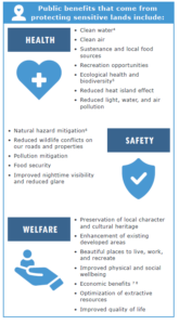
SENSITIVE LANDS PLANNING: PROTECTING PUBLIC HEALTH, SAFETY, AND WELFARE FOR GENERATIONS TO COME
April 28, 2021 by admin
Environmental, Policy/Legislative, Rural Planning
INTRODUCTION
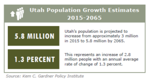
Mountains, lakes, forests, red rock vistas, and beautiful valleys have long attracted population growth, tourism, recreation, and economic development to the state of Utah1. The variety of unique and attractive landscapes, among other factors, have made Utah one of the fastest growing states in the nation and by 2065 the population is estimated to reach 5.8 million people2. Citizens, elected leaders, and practitioners all play a key role in balancing development pressures with land conservation priorities.
Planning to protect sensitive lands limits human development and activity but also protects people and their property. Landowners, citizens, developers, elected officials, and local government staff must recognize that restrictions on sensitive lands are guards against factors that could threaten the life, health, and safety of the public if developed. Sustainable land use practices guide development and preserve what makes our communities unique while protecting public health, safety, and welfare for generations to come.
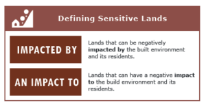
WHY SO SENSITIVE?
While some would argue that natural landscapes,
(like people) have feelings, the term “sensitive” actually refers to:
1.Lands that are susceptible to negative impacts from the built environment and its residents or;
2.Lands that can negatively impact
the built environment and its residents.
In other words, sensitive lands are areas where we should consider avoiding development altogether, or areas on which we should modify the intensity or type of development.
A prime example of how development can negatively impact, or be negatively impacted by the local landscape is bench development. Hillsides, ridgelines, and benches that overlook Utah’s beautiful valleys are often popular construction sites due to their spectacular views and easy access to the mountains. While bench-life may seem appealing, the environmental impacts of bench development are more significant than many of us realize.
Deer and elk naturally utilize benches as winter range, calving areas, and as natural corridors to move between elevations at different times of year. Benches also serve as groundwater recharge zones for local aquifers that supply drinking water to our cities and towns. As development becomes more dense in these sensitive areas, local stream corridors often become channelized or piped which reduces the stream’s ability to
DON’T BENCH ME
A prime example of how development can negatively impact, or be negatively impacted by the local landscape is bench development. Hillsides, ridgelines, and benches that overlook Utah’s beautiful valleys are often popular construction sites due to their spectacular views and easy access to the mountains. While bench-life may seem appealing, the environmental impacts of bench development are more significant than many of us realize.
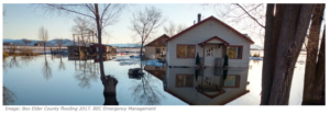
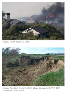
Deer and elk naturally utilize benches as winter range, calving areas, and as natural corridors to move between elevations at different times of year. Benches also serve as groundwater recharge zones for local aquifers that supply drinking water to our cities and towns. As development becomes more dense in these sensitive areas, local stream corridors often become channelized or piped which reduces the stream’s ability to naturally flow, filter sediment and pollutants, and percolate into local springs and wells. The inability of a stream corridor to function naturally increases flood risk to homes and properties during high rainfall or snow melt events.
In addition to wildlife habitat, water quality, and drainage degradation, bench, ridgeline and hillside development can result in soil erosion and sedimentation, increased wildfire risk, unattractive slope scars, and decreased access to recreational opportunities and open space3. This singular example isn’t to say that property owners shouldn’t develop their bench properties. Rather, they should consider reducing the intensity of development and look at the environmental impacts holistically and intentionally.
MULTIPLE TYPES AND MULTIPLE BENEFITS
Besides steep slopes and ridgelines, sensitive lands in Utah can also include: wetlands, stream corridors and riparian areas, source water protection zones, prime agricultural lands, critical wildlife habitat, beautiful viewsheds, pristine dark skies, community gateways, cultural and historical amenities, and natural hazard areas, just to name a few.
IDENTIFYING SENSITIVE LANDS
Identifying which landscapes are critical or sensitive is based on local values and needs as well as known best practices. Local goals and objectives can be determined through community surveys during a General Plan update, from public meeting input, local studies or plans, or from other sources. One of the easiest ways to begin identifying sensitive lands is by creating a map utilizing existing datasets. These datasets often come from federal, state, county, municipal, or other local sources. Some of the more common
sensitive lands GIS datasets available include:
• Prime Agricultural Lands
• Natural Hazard Areas (floodplains, geologic hazards, wildfire, etc.)
• Viewsheds (using available digital topographic datasets)
• Recreation Resources
• Wetland/Riparian Areas
• Wildlife Habitat
If data are not readily available, communities can create their own datasets or hire consultants to map resources that are important to them. Local universities may also have existing datasets or have the resources to create data, sometimes for a nominal fee. Less common datasets that may need to be mapped include items such as community gateways, local source water protection areas, local historic structures or cultural assets, locally significant landscapes, or others.
ALL PART OF THE (GENERAL) PLAN
Simply identifying sensitive land locations is not enough when it comes to guiding future development and land use. Whether for conservation or protecting future development from natural hazards, sensitive lands should be directly integrated into local land use plans and ordinances. If sensitive lands are not included in the General Plan it becomes very difficult to include zoning and ordinances that protect sensitive areas since, legally, land use policies should reflect the local values, goals, objectives, and strategies included in the General Plan.
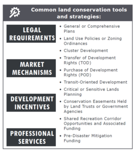
COMMON TOOLS AND STRATEGIES
Land conservation tools and strategies may consist of legal requirements, market mechanisms, development incentives, or professional services9.
For an overview of conservation tools for local governments, watch this presentation given by Christopher Sands, Principal and Senior Planner at BIO-WEST, Inc. at the 2020 Cache Summit held in Logan, Utah: https://youtu.be/D2_SUQ_9GjU
IN CONCLUSION
While sensitive lands planning has been used by some Utah communities to help preserve important landscapes and protect local residents, many of our communities only mention them tangentially in local land use plans and/or ordinances. As these lands are developed, costs to retroactively mitigate impacts from natural hazards or to preserve or restore lands that provide natural ecosystem se
rvices become very high and are extremely difficult to implement. Integrating sensitive lands planning early on in the planning process is critical to protecting the health, safety, and welfare of local residents. Likewise, as these lands are identified based on local community values, various tools can be utilized to purchase or preserve them for generations to come.
If you are interested in learning more or being part of the sensitive lands planning conversation, the Utah Community Development Office (CDO) is currently working with various groups and organizations from around the state to create sensitive lands planning tools geared towards Utah communities. Likewise, if you know of local examples of effective sensitive lands planning and implementation projects, we would love to include those in the various resources being created.
Please contact Aubrey Larsen with CDO at aubreychristensen@utah.gov, or Zac Covington with BRAG at zacc@brag.utah.gov.
Recent News
- » APA UT- Call for Nominations
- » 2024 APA UT Spring Conference: Cedar City, UT. The Call For Sessions is Currently Open.
- » Planning In The News- Opinion: As a commuter who can’t afford to live in Salt Lake City, I still deserve to be heard
- » Hurry, it’s the final week to grab your conference tickets at regular prices!
- » Planning in the news: BYU students aim to eliminate parking woes through AI tracking system
- » Planning in the news: Living in Daybreak- What residents say the Utah community is really like